

UPDATE: On Saturday afternoon, a Winter Storm Warning was issued for Niagara, Orleans, Northern Erie and Genesee counties from 1 p.m. Sunday to 4 p.m. Wednesday. A Winter Storm Warning was also issued for Wyoming, Chautauqua, Cattaraugus, and Southern Erie counties from 7 a.m. Monday to 4 p.m. Wednesday.
The National Weather Service says heavy snow and blowing snow are expected with total snow accumulations of 10 to 20 inches. Winds will gust as high as 50 mph, creating blowing and drifting snow.
Below you can find 7 Weather meteorologist Autumn Lewandowski's breakdown from Friday afternoon when a Winter Storm Watch was issued.
ORIGINAL: Cold air dives into WNY from Sunday into early next week, setting the stage for lake effect snow. Winds gusting near 45mph will cause poor visibility and blowing and drifting snow.
A Winter Storm Watch is posted for Niagara, Orleans, Genesee, Erie, Wyoming, Chautauqua and Cattaraugus county from 7pm Sunday through 4pm Wednesday. 7"+ snow or more is possible in most persistent bands.
- The difference between a watch and warning is the time-frame
- Being 48 hours out from the start of the event is giving a "heads up"
- More than 7" is likely; 7" is just the threshold for the watch
WATCH: Winter Storm Watch issued for most of WNY from Sunday night to Wednesday afternoon
The next bout of cold arctic air comes crashing into WNY late Saturday night and lasts into early next week.

With Lake Erie wide open and such a cold air mass overhead, there will be enough energy/moisture for lake effect snow. This will trigger a lake response over several days with bands meandering across WNY.
Since this event is several days away, placement of snow bands and the highest totals are not at all set in stone. In fact, two of the most looked at models have different outputs as to where the most snow will be. What is agreeable between the two is that there is a lake response over several days with a foot or more possible.
Here's a look at the GFS:
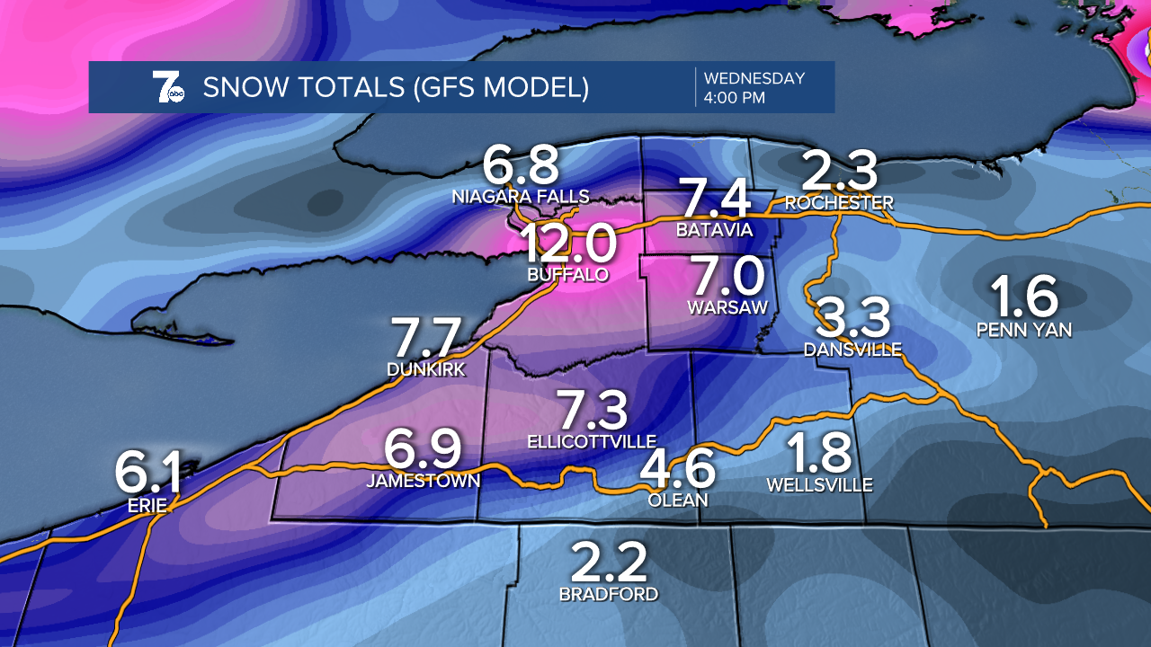
This places lake snow over metro Buffalo and Northtowns later Sunday and into Monday with higher totals through Ski Country as well.
Here's the European model:

This does place lake snow over metro Buffalo as well, but not for as long a duration, with the majority falling across the Southtowns and Boston hills and the Chautauqua Ridge.
What to take away from this "heads up"
- Lake snow begins Sunday, likely impacting Buffalo and the Northtowns for a time
- Winds gusting near 45 mph will create poor travel
- Conditions will widely vary across WNY because of lake bands
You can check the latest weather updates here from our 7 Weather Team
